Sundance Film Festival 2027
Map Design, Usability & Transportation Update
Delivery Date: October 14, 2026
Review Period: October 15, 2026 – October 25, 2026
Status: Submitted for Sundance Review
Overview
MCB has prepared an updated version of the Sundance Film Festival 2027 interactive map incorporating the design, navigation, usability, accessibility, and classification refinements identified during Sundance’s previous review.
This delivery also incorporates additional festival-related location information, sponsor identification, hotel listings, and transportation data supplied by the City of Boulder.
The purpose of this review is to confirm the updated map experience, identify any remaining corrections, and establish the current implementation baseline as preparations continue toward the January 2027 festival.
Map Version Under Review
Baseline Date: October 14, 2026
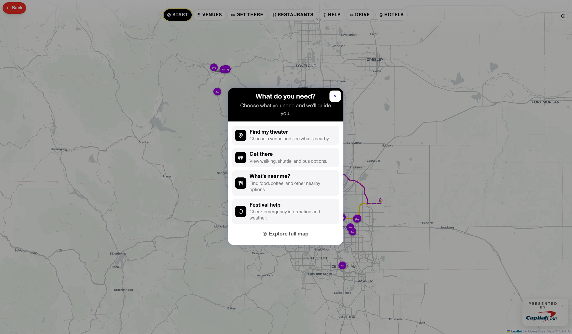 Click to open full map
1. Design & Visual Identity
The updated map reflects Sundance’s requested visual direction, including:
- Updated Sundance loading-screen logo treatment.
- Application of Sundance's primary black, white, and gold visual palette.
- Revised typography and text sizing.
- Simplified interface colors and presentation.
- Improved map contrast, readability, and visual hierarchy.
- Updated icon treatments, with standardized category-specific symbols and colors.
- Revised listing panels and information presentation to distinguish content from interactive controls.
2. Navigation & User Experience
Updates address the navigation and discoverability issues identified during the previous review, including:
- Revised primary navigation and category organization.
- Clearer access to comprehensive map information.
- Updated venue classifications and navigation labels.
- Refined transit, parking, and location filters.
- Improved visibility of interactive controls, expanded details, and close buttons.
- Streamlined listing layouts across mobile, tablet, and desktop experiences.
- Improved presentation of expanded location information.
3. Location Categories & Festival Information
The map has been updated to support the distinction between festival location categories, including:
- Film venues
- Event venues
- Sponsor and partner venues
- Festival services and locations
- Restaurants and nearby amenities
- Hotels and accommodations
- Parking and transportation locations
These classifications provide the foundation for continued additions and updates as remaining festival information becomes available.
4. Sponsor & Hotel Information
Sponsor identification: Sponsor logo placement has been added to the current implementation. Associated sponsor card information remains pending submission.
Hotels: Hotel locations have been added to the map. Associated hotel contact information remains pending submission.
The absence of these outstanding details should not be treated as an error in the current delivery. They will be incorporated following receipt and validation of the corresponding information.
5. City of Boulder Transportation Updates
The current map incorporates the additional transportation information supplied by the City of Boulder, including:
- Bike-share information
- Transit information
- Corresponding map locations and transportation representations
This review provides an opportunity for Sundance and relevant City stakeholders to confirm the accuracy, placement, classification, and presentation of the newly incorporated information.
Any future changes to transportation operations, routes, schedules, or associated data will be handled through the continuing update process.
6. Accessibility & Cross-Device Experience
The updated interface includes refinements addressing the accessibility and usability observations raised during the prior review.
Reviewers are encouraged to examine readability, contrast, icon legibility, navigation behavior, interactive controls, and expanded listing information across desktop and mobile devices.
7. Items Pending Additional Information
The following information is not part of the completed data submission represented by this review:
| Component | Pending information |
|---|---|
| Sponsor | Associated card data |
| Hotels | Associated contact data |
| Festival information | Subsequent additions or changes submitted through the project workflow |
| Transportation | Subsequent updates supplied by the responsible data sources |
These items remain open for incorporation and do not prevent review of the components currently delivered.
8. Review & Feedback
Sundance and designated stakeholders may review the updated map and submit corrections or observations during the review period.
Please focus on:
- Accuracy of the design and usability revisions.
- Navigation, classification, and filter behavior.
- Venue and location placement.
- Sponsor and hotel representation.
- City-supplied transit and bike-share information.
- Any remaining visual, accessibility, or functional discrepancies.
Feedback should distinguish corrections to information or functionality currently delivered from new information or additional functionality requested for subsequent implementation.
Review Deadline: October 25, 2026
Review Notes
Please use review notes for corrections or issues affecting the current delivered baseline. Future additions or requests for subsequent phases may also be documented but should be identified as future work.
Submitted Notes (4)
Is it possible to add Vegan as a dietary option to both the restaurants page on the map and the https://sunins.mcbmap.com/submit-restaurant page? As an FYI other than this suggestion the team are happy with this landing page
10/22/2026 MEETING NOTES - Increase the contrast of the Filters control to make it more prominent and ensure users recognize that additional map layers can be activated. -Add a link within the Lodging section directing users to Sundance's lodging webpage. Open the link in an external browser to accommodate the mobile app experience. - Rename the current "Drive" filter to "Getting to Boulder" to clarify that it contains routes into Boulder rather than general driving directions. - Expand the emergency resources directory to include relevant hospitals, medical facilities, law enforcement, fire, and rescue services in surrounding communities, including Broomfield and Longmont. - Partner venues and screening theaters will be assigned distinct categories through the backend editor, with the corresponding pin styles applied automatically. - Backend editor correction: Investigate and resolve the issue requiring users to cancel or refresh when switching between venue records. - Evaluate relevant transportation connections from surrounding communities, particularly Broomfield and Longmont, without adding unrelated Denver-area routes that would clutter the map.
Because there is no edit section for review notes following up here In the previous comment I didn't take into account the dynamic nature of each section (example selecting "Drive" has driving routes menu etc) So you can ignore the toggle request (Ability to turn on / off independently) however the need here is to be able to see the following together and in any combination - Venues - Transit - Parking - Live Buses - Bicycle - Hotels (To be renamed lodging) - Restaurants The idea being, how far is my hotel from the venue I am going to or what restaurants are near the venue I am going etc. I think you get the idea Another point I would reccomend not have independent zoom levels for each pill, just retain whatever zoom and position the users are at when switching between sections That said with all of this, the goal is to make navigating as easy and intuitive as possible so if there are parts that don't make sense let Beckah know and we can talk it through
- Make toggle pills independent on/off switches so uses can add and combine map items as needed with the exception of the "Start" pill that should uncheck all selected and recenter view - Start View - Default view to be centered / Zoomed into Boulder region (At a zoom level were all venues can be visible on screen) - ONLY have Venues and Transit enabled, with stops hidden (Everything else should also be hidden) - Get There - Add a stops toggle so you can hide / unhide bus stops - If we update the pills to be independent toggles then the Bicycle pill should only be turned on if pressed by the user, so Bicycle pins are not enabled when selecting GET THERE - HOTELS > rename to LODGING - Might be worth adding a link to the lodging site somewhere in this lodging section? Use your judgement there if it makes sense from a UX perspective. https://lodging.sundance.org/lodging?lang=en&Checkin=&Checkout=&Rooms=a2-c0&Pets=&PromoCode=&affiliate=&Code=&GuestsAdult=&GuestsChildren=
9. Milestone Approval
Final approval of this delivery milestone is reserved for Seth.
Approval confirms acceptance of the updated implementation baseline represented by this review, subject to any documented exceptions.
Approval does not constitute final acceptance of the January 2027 production map. Outstanding sponsor and hotel details, subsequent festival data, transportation changes, and later-phase implementation will continue through the established project workflow.
At the conclusion of the review period, this milestone will close for billing purposes in accordance with the applicable agreement.
Authorized Approval
Status: Approved
Approved by: Seth Arora
Approved: 11/2/2026, 3:06:20 PM
Baseline approved: October 14, 2026
Approval will be recorded with the date and time of submission.